Showing 63 items matching early dwelling
-
 Phillip Island and District Historical Society Inc.
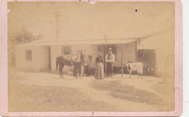
Photograph, early 1900's
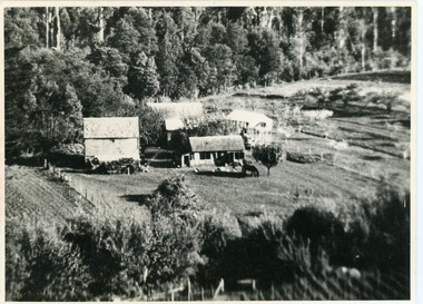
... early dwelling...Three people standing outside early dwelling. Horse, cow... dwelling. Horse, cow and dog in photo. group photograph early ...Three people standing outside early dwelling. Horse, cow and dog in photo.Photograph of group of 3 people in front of farmhouse? with a horse, dog and cow. Very tall Chimney.group photograph, early dwelling -
 Camperdown & District Historical Society
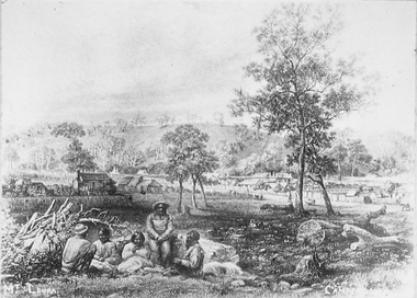
Photograph - Etching of early Camperdown scene, Mt Leura Camperdown, c1850s
... a group of First Nations people and early dwellings and native... a group of First Nations people and early dwellings and native ...This etching was created of Camperdown c1850s showing a group of First Nations people and early dwellings and native vegetation around Mounts Leura and Sugarloaf. Camperdown was surveyed by Robert Dunbar Scott in 1851. First dwelling constructed by David Fenton in 1853 on site of Commercial Hotel. Etching of early Camperdown scene showing group of First Nations people in the foreground with early buildings, native vegetation and Mount Leura and Mount Sugarloaf in the background. On front: Mt Leura, Camperdowncdhs, djargurd wurrung, djargurdwurrung, mount leura, mt leura, mount sugarloaf, mt sugarloaf, cdhsfirstnations -
 Camperdown & District Historical Society
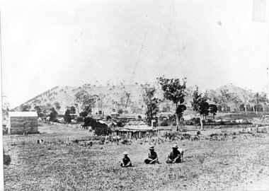
Photograph - Aboriginal people at Mt Leura, Camperdown, c1875
... of Mt Leura, Camperdown c1875. This image also shows early... of Mt Leura, Camperdown c1875. This image also shows early ...Three Djargurd Wurrung people on Country, pictured in front of Mt Leura, Camperdown c1875. This image also shows early primitive dwellings, Ower's flour mill (built 1868) and surviving native vegetation. Image of three Djargurd Wurrung people seated in front of Mt Leura, Camperdown, taken near corner of Scott and Curdie Streets c1875. On back: Early 1870s, Bought at first land sale Cr Scott & Curdie St, F.H. Grant, 11 Adeney Streetcdhs, djargurdwurrung, wombeetch puyuun, camperdown george, prince charlie, mount leura, mount sugarloaf, mt sugarloaf, ower's mill, cdhsfirstnations -
 Buninyong & District Historical Society
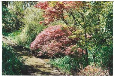
Photograph - Original Colour Photograph, Ann Beggs Sunter, Gardens at Lal Lal House, Yendon, October 1993
... Early settlers, Fisken family's dwelling...., Japanese Maple with autumn foliage centre. Early settlers, Fisken ...Early settlers, Fisken family's dwelling.Colour photo part of Garden at Lal Lal House, Yendon, cottage-style garden, gravel path curving to left, Japanese Maple with autumn foliage centre.lal lal house, yendon, garden, fisken -
 Buninyong & District Historical Society
Photograph - Original Colour Photograph, Ann Beggs Sunter, Lal Lal House, Yendon, side view, October 1993
... Early settlers, Fisken family's dwelling.... story, red brick, gabled tin roof Early settlers, Fisken ...Early settlers, Fisken family's dwelling.Colour photo Lal Lal House, Yendon, Victorian single story, red brick, gabled tin rooflal lal house, yendon, garden, fisken -
 Mt Dandenong & District Historical Society Inc.
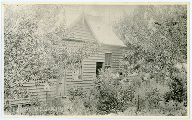
Photograph, Home and Shop of Edward Joseph Price
... of earlier dwelling from which goods had been sold without a special... Price LOT 1 SECT 1 erected in 1908 on site of earlier dwelling ...John Lundy-Clarke grew up in the Kalorama/Mt Dandenong area and later in life (1972-74) began to write a comprehensive history of the district working from an original settlement map in an effort to cover all areas. Edward Joseph Price was the first settler to take up a lot (Lot 1, Section 1) in the Village Settlement. He built a slab hut and brought up his family in 1896. This photograph shows a newer home built in 1908. It had a section used as a shop and also had a large room built that was to be used for public gatherings. Health department regulations led to this being impossible. The house faced Ridge Road.Black and white close up photograph showing a building made from wooden boards with trees in the front. Reverse of photograph has handwritten description by John Lundy-Clarke.On Front STORE MT DANDENONG On Reverse Home and Shop of Edward Joseph Price LOT 1 SECT 1 erected in 1908 on site of earlier dwelling from which goods had been sold without a special room for shop. In picture the room on the extreme left was bedroom for boys Charlie and Ted (Edward John). Under the gable was a large room planned for public use but never used owing to Health Department Regulations. The narrow door (open) and window were the shop which was the district’s first newsagency. Window behind leaves at right was the kitchen. 1908-1912. Gabled portion is now part of home “Mirra Laken” 1975edward joseph price, store, shop -
 Eltham District Historical Society Inc
Slide - Photograph, Second Life, 736 Main Road, Eltham, c.May 1988
... a streetscape recognisable from that earlier time. The side dwelling... that earlier time. The side dwelling illustrates the common practice ...The c1920 brick shop and side dwelling is one of just three early 20th century shop buildings left in Eltham and one of just two that have intact facades. These shops are physical links with the country village of Eltham at that time and their siting in isolated locations along the street reflects that village era. Since the 1950s Eltham's main street has changed dramatically and the intact pre 1940 buildings such as this shop are key components of the section of Main Road south of Henry Street which still has a streetscape recognisable from that earlier time. The side dwelling illustrates the common practice of that time for shopkeepers to live at their premises. In the 1990s this was an antique Shop and in 2010 “Eltham Cycles”. It is now a popular eatery – Zen Den. 35mm colour positive transparency (1 of 23) Mount - Kodak EktachromeProcess Date MAY 88Meltham, main road, antiques and old wares, cafe zen den, restaurants, second hand dealer, second life decor pty ltd, shops -
 City of Moorabbin Historical Society (Operating the Box Cottage Museum)
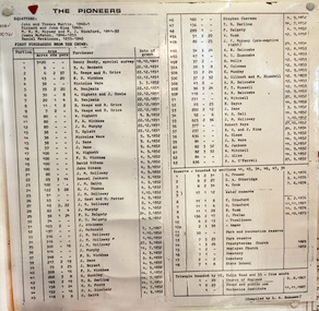
Document, laminated List of Pioneers Moorabbin Parish, c1985
This list shows the names of the Pioneer settlers with the amount of Acres, the date purchased from The Crown and the Lot or Portion Number in the Land of the Henry Dendy Special Survey of Brighton 1841, in the County of Bourke , Victoria. The Squatters ,who arrived in the area first, used the land for grazing sheep and cattle. The Squatters had the right to graze unoccupied Crown land for ₤10 per year rental and a per capita payment for animals grazed. They could develop , improve and clear the land for the purpose of the tenancy but ownership was not permitted. When the land became useful The Crown put it on the market and the developers took over whilst the Squatters lost the improved land, dwellings and out buildings, there being no compensation paid. Squatters named John and Thomas Martin 1840-41; Richard and John King 1840- 1854 ; M.N.M.Moysey and M.J.Bickford 1841-1852 ; James McMahon 1846-1853 ; Daniel MacKinnon 1839- 1840. The 5120 Acres of the Henry Dendy Special Survey 1841were divided into approx. 83 Portions / Lots with varying acreage . Josiah Holloway, a speculator purchased 625 acres of the King Brothers run and re-sectioned the land into 2 acre Lots for Sale as market gardens. It was called The Two Acre Village later known as Cheltenham. A List of the names of The Pioneers in County of Burke Victoria c1841-1887 compiled by Lesley A. Schumer in 1985 A 3 Laminated display on wall in room 2 THE PIONEERS, Signed L.A. Schumer moorabbin, brighton, cheltenham, bentleigh, market gardeners, pioneers, early settlers, dendy henry, henry dendy's special survey 1841, squatters, king john, martin john, mcmahon james, two acre village, holloway josiah, were jonathan binn, grazing, cattle, sheep, market gardens, -
 City of Moorabbin Historical Society (Operating the Box Cottage Museum)
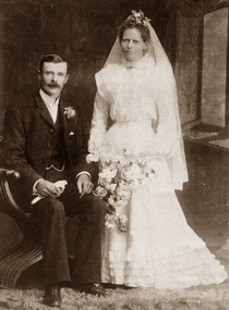
Photograph, B&W, George William Box & Elizabeth Honor Tippett Wedding 1902, c1902
Box Cottage Museum, a reconstruction of an early settler hut, is named after the Box family who resided there 1865 -1913 . George William Box 1870 -1933 was a son, and twin brother of Cecilia Eliza, of William and Elizabeth Avis Box who lived in Box Cottage and farmed the land 1865 - 1913 . George William Box married Elizabeth Honor Tippett 1902 and they had 8 children. Elizabeth Avis Box gave them a shop with a dwelling in Jasper Road where Elizabeth Honor sold groceries and vegetables while George obtained various jobs. Box Cottage Museum, a reconstruction of an early settler hut, is named after the Box family who resided there 1865 -1913 . George Box was the father of William Box who with his wife Elizabeth Avis Box and 13 children lived and farmed on the block of land in Jasper Road, East Brighton ( now McKinnon / Ormond) that was part of the Henry Dendy Special Survey 1841 Inscribed inside Album : “ The early photos in this album were found by Mr (Laurie) Lewis when he was demolishing the Old Box Cottage. He gave them to Mrs Avis Box Eldridge who in turn gave them to me. They were not identified. I believe they rightly belong in the Cottage. I have attempted to identify them and present them in a way they can be preserved as a historical record of the era.” A B Leigh A black & white Wedding photograph 1902 of George William Box 1870-1933 and Elizabeth Honor Tippet Box d1953TALMA 119 Swanston Street / Melbourne / and at Sydneybox george, box mary, box william, box elizabeth, box alonzo, box mary louisa, dendy henry, were j b, dendy's special survey 1841, brighton, moorabbin, bentleigh, mckinnon, ormond, market gardeners, dairy farms, early settlers, pioneers, jasper road, gurr jabez, gurr eliza, pay henry, pay anna, ward willam, box henry, ward elizabeth emma, box john, sheldrake martha, rushall eleanor, box caroline, box william, box elizabeth avis -
 Greensborough Historical Society
Photograph, Home of Mr Coghill Greensborough, 1910c
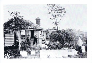
... . This shows the type of dwelling the early settlers lived in, also ...Shows the home of Mr Coghill which was the former Mitchell house located between the railway line and the Plenty River and directly opposite the end of Jessop Street.This shows the type of dwelling the early settlers lived in, also what they had in their cottage gardens.A rectangular black and white photograph of 4 men and 1 woman in a garden outside a shingle hut with bee hives near them.shingle hut, cottage garden, bee hives, coghill, mitchell, 1910 -
 Greensborough Historical Society
Photograph - Digital image, Marble Hall, 1930-1940
Photograph of "Marble Hall", Greensborough. The Marble Hotel, Greensborough was located at the corner of Main Street and Para Road. The first licensed hotel in Greensborough and one of the earliest brick buildings was built by James Chapman in the early 1850s as a hotel and lodging house to cater for wood carters and those trying their luck at the gold fields but served many functions over the years including post office, general store, public hall, butchers, bakers, surgery, private dwelling and baby health care centre. It got its name due to its white washed exterior. This photo is from the Lorraine Coates Collection.Photograph of early Greensborough building, now demolished.Digital copy of black and white photograph.marble hotel greensborough, james chapman, marble hall greensborough -
 Greensborough Historical Society
Photograph - Digital Image, Happy Hollow plaque, 05/02/1840o
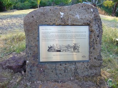
The land surrounding Happy Hollow farm at Plenty was purchased by Francis Wickham in 1840. The land was later subdivided and held by various owners including Charles Partington (1875) and John McLaughlin who leased the property in 1892 to Robert Emmett Whatmough who erected the first dwelling on the property. The land was later owned by Mrs Betty Bell and was purchased by Parks Victoria in 1994 to form part of the Plenty Gorge Parklands. This plaque was laid by Plenty Historical Society.Happy Hollow was an example of early settlement along the Plenty River.Digital copy of colour photograph. Plaque at Plenty Gorge Parklands.plenty river, happy hollow, happy hollow farm, robert emmett whatmough, betty bell, john mclaughlin, charles partington, parks victoria -
 Greensborough Historical Society
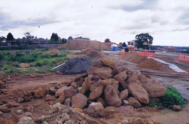
Photograph - Digital image, Frank Solomon, Development of pig farm to residential blocks, 1, 02/08/2009
A view of the redevelopment of the pig farm in Weidlich Road Greensborough, owned by Werner Hanusch. The land was used as a pig farm and quarry from 1954 and this photo shows early stages of the land being subdivided into the Evelyn Way estate. This project of fifty, one double storey, dwellings was commenced on 2/8/2009 and completed on 6/2/2011.An example of the changing land use in Greensborough, from farming to residential.Digital copy of colour photographwerner otto fritz hanusch, pig farm st helena, weidlich road greensborough, one evelyn way greensborough -
 Greensborough Historical Society
Photograph - Digital image, Frank Solomon, Development of pig farm to residential blocks, 2, 02/08/2009
A view of the redevelopment of the pig farm in Weidlich Road Greensborough, owned by Werner Hanusch. The land was used as a pig farm and quarry from 1954 and this photo shows early stages of the land being subdivided into the Evelyn Way estate. This project of fifty, one double storey, dwellings was commenced on 2/8/2009 and completed on 6/2/2011.An example of the changing land use in Greensborough, from farming to residential.Digital copy of colour photographwerner otto fritz hanusch, pig farm st helena, weidlich road greensborough, one evelyn way greensborough -
 Greensborough Historical Society
Photograph - Digital image, Frank Solomon, Development of pig farm to residential blocks, 3, 02/08/2009
A view of the redevelopment of the pig farm in Weidlich Road Greensborough, owned by Werner Hanusch. The land was used as a pig farm and quarry from 1954 and this photo shows early stages of the land being subdivided into the Evelyn Way estate. This project of fifty, one double storey, dwellings was commenced on 2/8/2009 and completed on 6/2/2011.An example of the changing land use in Greensborough, from farming to residential.Digital copy of colour photographwerner otto fritz hanusch, pig farm st helena, weidlich road greensborough, one evelyn way greensborough -
 Greensborough Historical Society
Photograph - Digital image, Frank Solomon, Development of pig farm to residential blocks, 4, 02/08/2009
A view of the redevelopment of the pig farm in Weidlich Road Greensborough, owned by Werner Hanusch. The land was used as a pig farm and quarry from 1954 and this photo shows early stages of the land being subdivided into the Evelyn Way estate. This project of fifty, one double storey, dwellings was commenced on 2/8/2009 and completed on 6/2/2011.An example of the changing land use in Greensborough, from farming to residential.Digital copy of colour photographwerner otto fritz hanusch, pig farm st helena, weidlich road greensborough, one evelyn way greensborough -
 Greensborough Historical Society
Photograph - Digital image, Frank Solomon, Development of pig farm to residential blocks, 5, 02/08/2009
A view of the redevelopment of the pig farm in Weidlich Road Greensborough, owned by Werner Hanusch. The land was used as a pig farm and quarry from 1954 and this photo shows early stages of the land being subdivided into the Evelyn Way estate. This project of fifty, one double storey, dwellings was commenced on 2/8/2009 and completed on 6/2/2011.An example of the changing land use in Greensborough, from farming to residential.Digital copy of colour photographwerner otto fritz hanusch, pig farm st helena, weidlich road greensborough, one evelyn way greensborough -
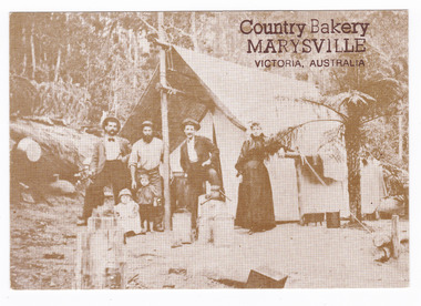 Marysville & District Historical Society
Postcard (item) - Black and white postcard, George Symons, Country Bakery, MARYSVILLE, VICTORIA, AUSTRALIA, 1990's
An early photograph of a miner and his family standing outside their tent in the Australian bush.An early sepia photograph of a miner and his family standing outside their tent in the Australian bush. This postcard was produced by George Symons as a souvenir of Marysville.AUSTRALIAN/ yesteryear/ CARDS P7 CORRESPONDENCE ADDRESS IN THEIR SUNDAY BEST c. 1880 A miner's family dressed in their Sunday best/ outside their tent dwelling./ Despite the difficulties of tent life the woman/ has brought her touch to the camp and is still/ able to dress her family immaculately for their/ Sunday stroll down the track. Photographer Unknown A sepia tone facsimile of/ an early Australian photographmarysville, victoria, mining life, australia, george symons, postcard, souvenir -
 Kiewa Valley Historical Society
Photographs and copies of photographs of the pack horses and early horsemen who transported supplies to outposts in the Bogong High Plains, via cattle tracks before access roads were made
In the mid to late 1930’s survey outposts were established to plot the early stages of the Kiewa Hydro Electric System for the SECV in the Bogong High Plains. Before any roads were built, the old cattleman’s tracks were used with packhorses to deliver supplies, wages and mail and collect timesheets and correspondence from the workmen and dam builders living in canvas tents and at the outlying survey posts. The trip up the mountain was long and hard and dangerous for both horse and man Most of the men of the survey teams were not bush-men and were often ill equipped for the harsh weather and living conditions of bush camping, often arriving in their city clothes ready for work. The tent city at Bogong was destroyed by bush fires in 1939 after which an access road was built from Mt Beauty to transport building materials for more permanent dwellings for workmen. Pack horses continued to be used for transporting goods etc. to workers further up the mountain.Without the work of horsemen and their pack horses providing supplies and communications for outlying outposts, surveying and early planning for the Kiewa Valley Hydro Electric scheme could not have gone ahead and the dams and power stations which support the system could not have been constructed. The Hydro-electric scheme, and the workers who planned and built it play a major part in the early history of the Kiewa Valley and many original families still remain living, or have ties with the local area.: Set of 21 black and white photographs and copies of photographs depicting the pack horses and the men who handled them, transporting supplies and correspondence to the outlying camps and survey posts in the Bogong High Plains, via the rough cattlemen’s tracks. Photographs also show the early tent camps of the workers. Some photos mounted on A4 white paper. Some photos enlarged to A3 poster size for display1. Handwritten on back – Max Lawrence 2. -8 No inscriptions 9. Handwritten on back- Packing in supplies for early workers of the Kiewa Hydro scheme. There were no roads in the early days of the scheme 10. Printed on bottom of photo- Roper’s cattle on road below Howman’s Gap 11. Handwritten on back – Roper’s et al about to leave for the high plains 12. Printed under photo- Syd Ryder at the Pretty Valley Cut-Out (JBR) 13-16. No markings 17. Printed under photo- Gwen Talbot visits the Camp area. 1937 18. Handwritten on back- 14/1 Barbara Talbot 19. No markings 20-21. No markings 22. Printed under photo- STATE ELECTRICITY COMMISSION OF VICTORIA. Date: 15-3-45 Time: 8.0pm No: K 1838 Kiewa Hydro-Electric Works, Investigations 1944-1945 – Survey Camp at Young’s Hut pack horses; bogong high plains; survey posts; supplies delivery -
 Kiewa Valley Historical Society
Photographs – Set of 4 black and white photographs. One of a wooden church and three of rural homes and farmland. Area not identified
... . These photographs provide a snapshot into the early dwellings ...Europeans arrived in the Kiewa and Ovens Valleys in the 1830's and 40's. Following the drought of 1838-44, seeking out the rich pastures in the fertile Valleys. It proved to be perfect conditions for dairy farming and the raising of cattle. Miners Cottages and other similar wooden structures were a common sight in the area as they were a modest form of accommodation for their period, were quick to erect and economical as they made use of locally available building materials such as local timbers.These photographs provide a snapshot into the early dwellings and architecture of the Kiewa and Ovens Valley regions, including buildings such as the church, which provided an important gathering place for social interaction, especially in these isolated areas.1-Wooden church building with no identification. Large tree in the foreground in front of church 2&3- Black and white photographs of farmland and assorted dwellings, mostly miners style cottages in a valley with mountains in the background. A bridge with wooden railings is visible over the river in the middle of the photograph, also a more modern dwelling is visible in the north east of the photograph close to the river. 4-Black and white photograph of residential homes and farmland with an unsealed road running through the middle. Foreground shows a field which has been semi cleared of trees (stumps remaining). In the background are larger farming properties with the road disappearing into the distant hills. This might be Old Tallangatta before the town was moved in 1956. 1-3 - No inscriptions 4- Signature written on back in lead pencil - Sandra Templebuildings; church; farmland -
 Orbost & District Historical Society
Postcard - post card, early 20th century
This postcard was produced as a black and white card titled, "Early 1900 - Bush Hut , Gippsland", in the early 20th century. The original card had a blank white rectangular strip on the right side of the photograph. This was for the message. There is little information with this item except for a note indicating that it was a hut at Newmerella. This is a pictorial record of a bark hut of the kind built by the early settlers of East Gippsland. Few early settlers could afford the time, or possessed the capital, to build any dwelling more impressive than a slab hut: Postcards form a vital part of social and historical records for researchers. A postcard showing a bearded man sitting on a stool outside a bark hut. There are various tools - a wheelbarrow and shovels, buckets, a panning dish and a saw hanging above him to the left. . It is in a bush setting and the photograph has been tinted.on back - POSTCARD - in red :"Essie & Ruby McKena. Emily Ville, Ascot Vale Road Flemington"dwelling-bush hut-bark -
 The Beechworth Burke Museum
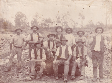
Photograph, c. 1870
This photograph was captured at an undisclosed location and at an unidentified time but likely dates to approximately 1870. The photographer's details are not recorded and the identities of the men in the image are also not known. This image depicts a group of 10 men in typical miners fashion. Four of them are sat on a large log with one holding a small dog. Six miners stand behind those sitting. All these men are wearing a white button-up shirt and tan coloured work trousers. They wear heavy boots and seven have included a dark vest over their shirt. The man holding the dog has a pipe in his mouth. Two of these men are clean shaven with the remainder sporting a moustache and two with a beard. The ages of these men vary from late 20s to middle age. This group of men are located in a mining location with what appears to be an open cut mine in the background of the image. The ground is muddy and has elements which can help identify it as a mining location based on the condition of the landscape. The bottom of the men's trousers are muddy which provides the assurance that these men were working in this location when their photograph was captured. In the background there is one structure, possibly a dwelling, and bush which identifies the location as Australia. Open cut sluicing is a method used to extract gold and other precious metals from beneath the surface of the earth. This technique involved the use of high-powered hoses which broke down the soil enabling miners to come along and search this soil for gold. After the gold rush of the early 1850s, diggers had to enlist the assistance of heavy machinery and techniques like hydraulic sluicing in order to reach gold because the surface alluvial gold had already been discovered and removed. This heavy machinery was not used until after 1853. The search for gold is ingrained into the history of Victoria and therefore, images like this one which portray an open cut sluicing site can reveal important information for society and technology for the date when the photograph was taken. This image is of important historical significance for its ability to convey information about sluicing and the methods used to find gold in the late 1800s and early 1900s. It also shows a location where sluicing was undertook which provides insight into the impact of sluicing on the environment at a time when it was done. Images, like this one, of Australian gold rush history can reveal important information about the social and environmental impact of this period. This image depicts diggers standing in a mining location and therefore, this image has the capacity to reveal or support significant information for researchers studying the fashion and social status of diggers in Australia in approximately 1870. It can also provide information on the landscape of Australia in this period and the impact of mining for gold on both society and the Australian landscape. The Burke Museum is home to a substantial collection of Australian mining photographs which can be used to gain a deeper understanding into life on the gold fields, technology used in mining, the miners themselves and the impact of the gold digging on the environment.Sepia toned rectangular photograph printed on matte photographic paper mounted on board.Reverse: 1997.2518mining, goldfields, beechworth, 1870, australia, australian goldfields, diggers, victoria, sluicing, gold mining, miners, diggers victoria -
 Victoria Police Museum
Police Stations (Apollo Bay)
Apollo Bay is a coastal town in southwestern Victoria. It is situated on the eastern side of Cape Otway, along the edge of the Barham River and on the Great Ocean Road, in the Colac Otway Shire. The original township was surveyed in 1853 and named Middleton. In 1881 the town was renamed Krambruk which was changed to Apollo Bay in 1898. The Krambruk Police Station was opened on 7 March 1888 in the Southern District on land opposite the site of the current Mechanics' Institute and changed its name to the Apollo Bay Police Station on 1 September 1990. It came under the Barwon District in 1948 and "Lima" Western District from 4 March 1990. In 1930 the police station was located to 29 Nelson Street. It was a seven-roomed weather-board dwelling on three-quarters of an acre of land. It consisted of six rooms of pine, lined and painted; one pantry; one bathroom and wash-house; one hall; one office and one W.C.. There was stabling for one horse and one cell for prisoners. It was staffed by one Mounted Constable. In the early 1970s land was acquired at 31 Nelson Street and a new police station was constructed. This was a three-roomed brick building with a cell block at the rear. By the time it closed in 2005 it had been extended twice. On 17 November 2006 the current Apollo Bay Police Station opened in its current location at 35a Nelson Street, on the corner of Cartwight Street). Outside the peak summer season, the station is open 16 hours per day and staffed by one sergeant and five other members. 3 black & white photos and 2 coloured photospolice stations; apollo bay police station -
 Warrnambool and District Historical Society Inc.
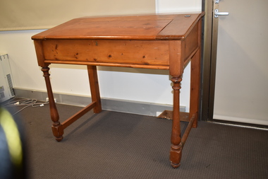
Furniture - School Teacher's Desk, Early 20th century
This is a teacher's desk which came from Woodford State School. The school began in 1854 in a private dwelling with a new building constructed in 1874. The school still operates today.This is a very fine example of an early 20th century school teacher's desk. As it comes from one of the earliest schools in the district, it is of considerable significance.This is a wooden desk, now varnished, with a lift up, slanted lid with brass hinges and a brass key hole. On the top right hand side is a brass insert with a porcelain ink well. The desk has four turned legs with end struts. The desk lid may be made of pine but the rest of the desk seems to be made of a different wood. There are signs of old borer on the left hand front and the curved part on that side is missing.woodford state school -
 Surrey Hills Historical Society Collection
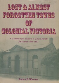
Book, Lost and almost forgotten towns of colonial Victoria: a comprehensive analysis of census results for Victoria, 1841 - 1901, 2003
Purchased from the author when he spoke at a meeting of the Surrey Hills Historical Society. This meticulously researched book lists all towns and villages with entries in the Victorian censuses between 1841 and 1901. There are over 1400 entries. It includes the latitude and longitude for each town. It indicates how many males and females lived in the town, and the number of occupied dwellings (where available). For many of these settlements the only visible trace of them today is in the census results collected by the fledgling governments of Colonial Victoria. It is a comprehensive reference and a fascinating insight into the movements of early populations of new Australians and the forces that shaped them and is useful to historians, researchers and all readers with a fascination for colonial history.This book lists all the towns and villages with entries in Victorian censuses between 1841 and 1901. There are over 1400 entries. 518pp, with place name index. cities and towns, ghost towns, victoria, 1841, 1901, angus b watson -
 Stawell Historical Society Inc
Photograph, Miners Small Brick Cottage -- early example in Curtis St
Small brick cottage a typical example of an early miners cottage located in Curtis Street. Mr. Hammer brickmaker, lived in the cottage. The cottage was also home to Mr. & Mrs. Vic Bullen for many years. Van Diesan later bought the cottage.Black & White photograph of a small brick college with corrugated iron roof. stawell dwelling -
 Port Fairy Historical Society Museum and Archives
Photograph
William and Emma Osmond with two small children arrived in Belfast in 1852 as assisted migrants assigned to R. H. Woodward . Two years later William was rated for a two room stone house in William street. By 1868 William Osmond was in business as a Butcher and was the holder of a Beer and Colonial wine license for his home which now numbered eight rooms. The license having been granted he opened the Volunteer Arms there, which he operated for two years whilst he had built, the two storied stone building next door, to take advantage of the fact that a livestock sale yards was operating on the opposite side of William street, hence the name Market Inn. William died in 1876 and his sons continued to run the hotel until 1916, when the building was sold and the license transferred to Harold Revell, a retired farmer. The license was revoked in 1918. and the building became a private dwelling . The building is still standing although the market for which it was named is long gone. It is now a private home and Art Gallery. the 4 people in the photograph are probably the Osmond sonsPhotograph of an earlier time when a verandah existed on the front and the butcher shop was attachedBlack and white photograph 2 photos exposed togetherhotel, osmond, william street, market -
 Mt Dandenong & District Historical Society Inc.
Photograph, Isaac Jeeves First Home, 1917
Isaac Jeeves arrived in 1857 to take up land. The photograph taken in 1917 shows his first home, which he left c1872. The small building in the right foreground was his first dwelling. On the left is a barn. Behind them is the roof of the house with the tree fern floor. The glass house came much later.Black and white photograph showing the first home of early settler Isaac Jeeves. Photo taken in 1917.isaac jeeves, isaac jeeves, jeeves, kalorama, pioneer -
 Surrey Hills Historical Society Collection
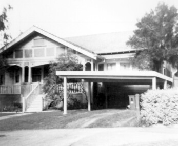
Photograph, 3 Norfolk Road Surrey Hills - home of Mr and Mrs Albert Ernest Vine
Albert Ernest Vine Snr, was a City of Camberwell Councillor from 1926-1934 and 1937-1944. He was also Mayor of Camberwell in 1940/41. There is a sundial in the Surrey Gardens erected in his memory. Known as Ernest, he and his wife Edith (nee Sword) lived at 3 Norfolk Road from 1920-1945. Earlier addresses are on file in Alan Holt card index. He was active in Surrey Hills Progress Association. He was the son of William James Vine (1860-1920) and Sarah Elizabeth Gunner (1859-1941). W J Vine & Co Timber Yards were located at 587-593 Canterbury Road. Elizabeth Gunner's brother was Henry Gabez Gunner (1862-1940), a builder in the Surrey Hills area. Box Hill Reporter (6/6/19) records that Ernest applied to Camberwell City Council for permission to subdivide land in Norfolk Road with a frontage of 85' into 2 equal lots for a dwelling to be erected on each, one for himself and the other for his mother. Albert Ernest & Edith Vine had the following children: Albert Ernest Jnr (b 1904), Robert (b 1908), Edgar (b 1912), Inez (b 1915) and Beth (b 1918). Both No 1 & No 3 were demolished c1970.Black and white photo of a 1920s style single-storey weatherbaord home with leadlight windows, a tiled roof and a wide veranda supported by timber columns on stucco pillars. The veranda has a simple timber balastrade and a flight of timber stairs to it. There does not appear to be front fence. A simple sloped double carport on the RHS and proud of the house is of a later date.norfolk road, californian bungalows, w j vine & co timber yards, mr william james vine, mr albert ernest vine, mrs edith vine, miss edith sword -
 Federation University Historical Collection
Document - Reports, Martin Westbrooke, Nanya Station
Nanya Station, owned and managed by the University of Ballarat (now Federation University Australia), was purchased with assistance from the Department of Environment and Heritage Government Caring for our Country program. Nanya Station is located in the Scotia country, west of the Darling Ana-Branch in far western New South Wales and consists of the Nanya Western Lands Pastoral Lease 3281 – Perpetual Leasehold Lot 1244 in Deposited Plan 762778, Parish of Winnebaga, County of Tara and part of Lot 1242 County of Windeyer. Nanya is within the tribal area of the Danggali Aboriginal people, a sub-group of the Barkindji. Many Aboriginal sites have been recorded adjacent to major rivers in the region providing evidence that these areas supported a large population. The Scotia region has one of the shortest stock grazing histories of western NSW. Along with five other Scotia properties, Nanya was created as a pastoral lease in 1927. The first European settlement on the land followed exploration of the area by Sturt and Eyre. In 1854, the Lake Victoria lease which encompassed this area comprised 465,000ha.included Scotia blocks 1, 2, 3 and 4, Amoskeag and Winnebaga which formed the area known as the Scotia. It was described as a region of thick mallee scrub, interspersed with bluebush flats and Belah woodland. In the 1920s artesian water was found and the dry Scotia country was surveyed and divided into six Homestead leases allocated by ballot (Withers 1989). All properties were approximately 30,000ha, with a recommended stocking level of 3,000 sheep. Winnebaga (renamed Nanya) was taken up by Gordon Cumming. He initially dug a dam near the southeast corner of the property. A larger ground tank and rudimentary dwelling at the site of the present complex was later established. An adjacent area was cleared and cropped to provide feed for the horses used in digging the earth tanks. The ruins of the original building are located between the shearing shed and Homestead Tank. A cottage was built in the 1930s and a more substantial Red Gum framed homestead in the early 1950s. The lease was held by Mr Gordon Cumming until 1984 when it was purchased by Mr Norm Scadding as an extension to the adjacent lease, Belvedere. It was sold in 1995 to Mr Rob Taylor of Waikerie then in 1999 to BeMax Pty. Ltd., a sand mining company. These last three owners all permitted use of the property by the University for teaching and research. The Centre for Environmental Management at the University of Ballarat had been involved in studies of flora and fauna in western New South Wales since 1988. Studies became concentrated on the Scotia region with its variety of intact ecosystems due to a short pastoral history. Of particular significance is a system of natural salt lakes of which the most extensive is the Scotia Discharge Complex located on Nanya Station. An extensive vegetation survey of the Scotia region Westbrooke et al. 1998) highlighted the significance of the area both in terms of the range of communities in relatively intact condition and the occurrence of species and communities of restricted distribution. Nearly 400 species were recorded of which nine had either not previously been recorded or have restricted distribution in western NSW. Twenty-two plant communities occur on Nanya Station of which two, Halosarcia lylei low open shrubland and Hemichroa diandra/Halosarcia/Frankenia low open shrubland, are dominated by species not previously recorded from NSW. H. lylei and Acacia loderi shrublands are listed as endangered under the NSW Threatened Species Conservation Act. As noted, the area has a relatively short grazing history and, due to the presence of large areas of mallee with a Triodia understorey and restricted water supplies, stocking rates have been low. The diversity of ecosystems in relatively intact condition and extensive areas of old growth mallee made Nanya a highly significant refuge for biological diversity. This factors led to the purchase of Nanya Station by the University of Ballarat in 2004 with the assistance of the Department of Environment and Heritage for the purposes of conservation, research and education. In 2010 the southern paddocks of Nagaella Station (10,000ha.) which lie along the northern boundary, were purchased with the assistance of Lower Murray Darling Catchment Management Authority and added to the Nanya lease to provide complete protection for the communities of the Nanya Discharge Complex and further high quality Malleefowl habitat. Four digital reports documents relating to Federation University's Nanya Station, Western New South Walesnanya station, scotia country, pastoral lease, winnebaga county, darling ana-branch, martin westbrooke, environmental education, nagaella station, lower murray darling catchment management authority, conservation research education, ian gribble, pat prevett, ian henderson, danggali